Datasets:

The dataset viewer is not available for this dataset.
Error code:   ConfigNamesError
Exception:    DataFilesNotFoundError
Message:      No (supported) data files found in IGNF/FRACTAL
Traceback:    Traceback (most recent call last):
                File "/src/services/worker/src/worker/job_runners/dataset/config_names.py", line 73, in compute_config_names_response
                  config_names = get_dataset_config_names(
                File "/src/services/worker/.venv/lib/python3.9/site-packages/datasets/inspect.py", line 347, in get_dataset_config_names
                  dataset_module = dataset_module_factory(
                File "/src/services/worker/.venv/lib/python3.9/site-packages/datasets/load.py", line 1904, in dataset_module_factory
                  raise e1 from None
                File "/src/services/worker/.venv/lib/python3.9/site-packages/datasets/load.py", line 1885, in dataset_module_factory
                  return HubDatasetModuleFactoryWithoutScript(
                File "/src/services/worker/.venv/lib/python3.9/site-packages/datasets/load.py", line 1270, in get_module
                  module_name, default_builder_kwargs = infer_module_for_data_files(
                File "/src/services/worker/.venv/lib/python3.9/site-packages/datasets/load.py", line 597, in infer_module_for_data_files
                  raise DataFilesNotFoundError("No (supported) data files found" + (f" in {path}" if path else ""))
              datasets.exceptions.DataFilesNotFoundError: No (supported) data files found in IGNF/FRACTAL
Need help to make the dataset viewer work? Open a discussion for direct support.
FRACTAL: FRench ALS Clouds from TArgeted Landscapes
FRACTAL is a benchmark dataset for 3D point cloud semantic segmentation. It is large, open, and diverse.
- The FRACTAL dataset is made of 100,000 point clouds from 5 spatial domains (French regions) and spans a total area of 250 km².
- FRACTAL was sampled from an original 17,280 km² of data from the Lidar HD program (2020-2025), with a simple but efficient sampling scheme that explicitly rebalances rare classes and concentrates challenging landscapes and scenes.
- It includes 100,000 Aerial Lidar Scanning (ALS) point clouds, spanning 50 x 50 m each.
- The point density is high: 10 pulses/m², 37 pts/m² on average, 9261M in total.
- The target classification has 7 semantic classes: other | ground | vegetation | building | water | bridge | permanent structure.
- Each point cloud is colorized with aerial images from the ORTHO HR®.
- Each data patch comes with detailed metadata including class histograms, elevation & elevation gain, and presence of specific landscapes or objects.
FRCTAL is presented in a data paper: FRACTAL: An Ultra-Large-Scale Aerial Lidar Dataset for 3D Semantic Segmentation of Diverse Landscapes
Dataset content
The FRACTAL dataset consists of a total of 100,000 patches: 80,000 in the train set, 10,000 in the val set, and 10,000 in the test set. Each patch is a point cloud of high density aerial Lidar (10 pulses/m², ~40pts/m²). Point clouds are vertically colorized with very high resolution aerial images at a 0.2 m spatial resolution, with near-infrared, red, green and blue channels. Lidar and imagery data were acquired over several years in distinct programs, and up to 3 years might separate them. The years of acquisition are given as metadata.
Class distribution
| Class | Train (%) | Val (%) | Test (%) |
|---|---|---|---|
| Other | 0.6 | 0.5 | 0.7 |
| Ground | 39.0 | 39.1 | 40.5 |
| Vegetation | 57.0 | 56.9 | 54.1 |
| Building | 2.8 | 2.8 | 3.3 |
| Water | 0.5 | 0.5 | 1.2 |
| Bridge | 0.1 | 0.1 | 0.2 |
| Permanent structures | 0.04 | 0.04 | 0.04 |
Dataset extent and train/val/test split
FRACTAL was sampled from 5 spatial domains in Southern France, spanning 17,280 km² in total (3456 km² each on average), and distant from at least 100 km from one another.
To define a common benchmark, we split the data into train, val, and test sets (80%-10%-10%). The 25 km² of test data was sampled from contiguous test areas defined in each spatial domain, spanning 1049 km² in total (210 km² on average). The 200 km² + 25 km² of train and val data were sampled in the remaining areas, with spatial stratified sampling.
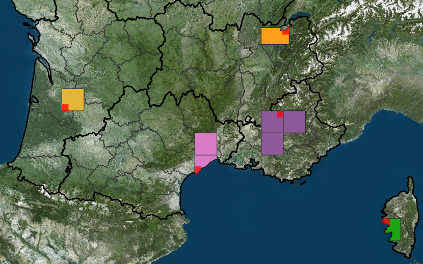 Sampling area considered to create FRACTAL. Test sampling areas are highlighted in red.
Aerial Images
The aerial images used for colorization of FRACTAL's point clouds are made available in a separate repository: [IGNF/FRACTAL-IRGB](https://huggingface.co/datasets/IGNF/FRACTAL-IRGB).
Citation
Please include a citation to the following Data Paper if FRACTAL was useful to your research:
@misc{gaydon2024fractal,
      title={FRACTAL: An Ultra-Large-Scale Aerial Lidar Dataset for 3D Semantic Segmentation of Diverse Landscapes},
      author={Charles Gaydon and Michel Daab and Floryne Roche},
      year={2024},
      eprint={TBD},
      archivePrefix={arXiv},
      url={https://arxiv.org/abs/TBD}
      primaryClass={cs.CV}
}
Dataset license
The "OPEN LICENCE 2.0/LICENCE OUVERTE" is a license created by the French government specifically for the purpose of facilitating the dissemination of open data by public administration. This licence is governed by French law. This licence has been designed to be compatible with any free licence that at least requires an acknowledgement of authorship, and specifically with the previous version of this licence as well as with the following licences: United Kingdom’s “Open Government Licence” (OGL), Creative Commons’ “Creative Commons Attribution” (CC-BY) and Open Knowledge Foundation’s “Open Data Commons Attribution” (ODC-BY).
- Downloads last month
- 1